Overview
|
|
.......................................
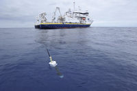
The broad-scale global array of temperature/salinity profiling floats, known as Argo, has already grown to be a major component of the ocean observing system. Deployments began in 2000. The name Argo is chosen to emphasize the strong complementary relationship of the global float array with the Jason satellite altimeter mission. For the first time, the physical state of the upper ocean will be systematically measured and the data assimilated in near real-time into computer models. Argo builds on other upper-ocean ocean observing networks, extending their coverage in space an time, their depth range and accuracy, and enhancing them through the addition of salinity and velocity measurements. |
Argo has several objectives. It will provide a quantitative description of the changing state of the upper ocean and the patterns of ocean climate variability from months to decades, including heat and freshwater storage and transport. The data will complement the Jason altimeter with measurements of subsurface temperature and salinity vertical structure and velocity information, with sufficient coverage and resolution to permit interpretation of altimetric sea surface height variability. more information on the program at Argo www site
Products
Argo data are provided by two Global DAta Centers (GDACs) , the Coriolis data center and USGODAE server , which serves both operational users and the research community with:
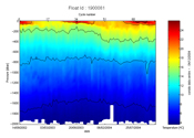
- Individual profiles acquired by the floats within 24h
- Delayed mode profiles corrected from bias and linear drift within one year
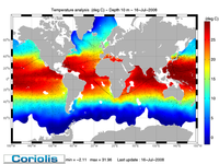
- Weekly Temperature and gridded analyses combined with other in-situ measurement
Research & Development
Argo data are used to initialize ocean and coupled ocean-atmosphere forecast models. A main focus of Argo is to document seasonal to decadal climate variability and to aid our understanding of its predictability. A wide range of applications is anticipated for the high-quality global ocean analyses that Argo makes possible.
Therefore work is carried out to improve delayed mode quality control procedure as well as to build new climatology and derive climate indicators.


